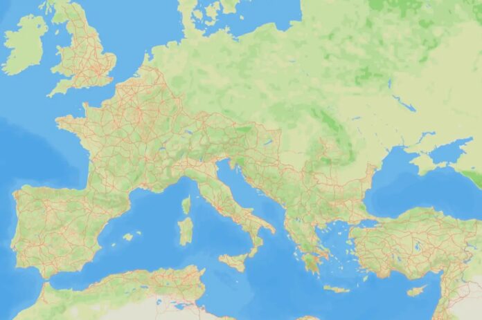
A new interactive map, called Itiner-e, has dramatically expanded our understanding of the Roman Empire’s road network, revealing a system almost 60% larger than previously estimated. This open-source dataset brings together centuries of historical records, topographic mapping, and satellite imagery, providing unprecedented access to the infrastructure that underpinned Roman power and trade.
The Creation of Itiner-e: Addressing a Significant Gap
The project arose from a long-standing frustration within the field of Roman archaeology. As Tom Brughmans at Aarhus University explains, “It’s like the most enigmatic topic in Roman archaeology. We even have proverbs that say, ‘All roads lead to Rome’. So why on Earth can’t I download all the Roman roads? Where are they?” The lack of a comprehensive and accessible dataset prompted Brughmans and his colleagues to compile and analyze existing studies, refining previously known routes and accurately tracing the network as it likely existed around AD 150.
The Scale of the Network: A Significant Increase in Known Length
The comprehensive analysis reveals a total road network length of approximately 299,171 kilometers. This is a considerable increase compared to the previous estimate of 188,555 kilometers documented in the Barrington Atlas of the Greek and Roman World. This highlights the importance of this new tool, and how much was previously unrecorded.
Uncertainty and Limited Precision: Challenges in Locating Roman Roads
While the map provides a robust overview, pinpointing the precise location of roads remains a challenge. The dataset shows that only 2.8% of the network’s length can be precisely located – within 50 meters in mountainous regions and 200 meters on flat land. This reflects a significant limitation, often due to the difficulty in securing funding for extensive road excavations and the repeated construction over Roman roads throughout history.
Myth-Busting: Straight Roads Were Not Always the Rule
The project also sheds light on a common misconception about Roman roads: their famed straightness. Catherine Fletcher at Manchester Metropolitan University notes that “Straight wasn’t always cheap or practical, especially through mountainous terrain.” Often, the Romans adapted existing routes rather than building entirely new ones, demonstrating a pragmatic approach to engineering.
Historical Significance: Roads as Drivers of Change
Improved knowledge of the Roman road system has the potential to reshape our understanding of pivotal moments in European history. The Roman roads facilitated the spread of early Christianity, mass migrations, and continent-wide pandemics – all transformative events heavily influenced by the efficiency of the road network. Brughmans believes the impact of the roads is often overlooked in favor of more visible artifacts such as amphitheaters and gladiatorial arenas.
“Roads often get overlooked because they aren’t as glamorous as amphitheatres and gladiators,” Fletcher notes, referencing a famous Monty Python scene highlighting the roads’ often-unacknowledged importance.
The comprehensive Itiner-e dataset offers an unprecedented opportunity for researchers, historians, and anyone interested in Roman history to explore the vast network that connected the empire.
The project’s findings were published in Scientific Data (DOI: 10.1038/s41597-025-06140-z) and provides a valuable resource for deepening our knowledge of the Roman world.


